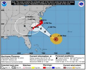
OCEAN CITY – Though Hurricane Florence appears to be making for a landfall farther south on the Eastern Seaboard, local officials are taking the threat of the potentially significant flooding the storm could bring seriously.
Worcester County officials advised residents in low-lying areas to prepare for the impacts of Hurricane Florence, which is now expected to begin influencing Delmarva late Thursday leading into the weekend. By Tuesday, several weekend events, including the Worcester County Fair and Delmarva Bike Week, had already been canceled. OC BikeFest activities have been relocated from the Inlet to the Roland E. Powell Convention Center.
A statement from Delmarva Bike Week last night read, “Regrettably, due to the threat of inclement weather, Delmarva Bike Week has moved activities to the Convention Center in Ocean City. This include activities at Purdue Shorebirds Stadium and Ocean Downs Casino. You can still obtain your free event pin at the Convention Center in Ocean City. We wish for the safest possible outcome for all. OC BikeFest is not cancelled at this time, the concerts will be taking place at Ocean City Convention Center. You can see and buy new Rommel Harley-Davidson Motorcycles Rommel Harley-Davidson Delmarva , as well as other vendors inside the convention center.”
Following Monday’s announcement that Gov. Larry Hogan had declared a state of emergency in Maryland in preparation of the storm, Ocean City officials said they’d already started readying for the storm, removing walkways and trash cans from the beach and closing the sea wall gates.
“Along with moderate wind and rain, the current path of Hurricane Florence will likely bring storm surges and tidal flooding, specifically in our A and B zones,” a Wednesday morning statement from the Town of Ocean City reads. “If you live in Zone A or B, PREPARE NOW by gathering supplies in case you have to leave immediately, or if services are cut off. Keep in mind each person’s specific needs, including medication. Don’t forget the needs of pets. Obtain extra batteries and charging devices for phones and other critical equipment.”
Residents can check their evacuation zones online so they’ll know when they should leave the area. The “Know Your Zone” program, which can be viewed at www.co.worcester.md.us, maps the county into three zones—Zone A, Zone B and Zone C. Properties in Zone A are those at the greatest risk of being impact during a hurricane.
“Worcester County is mapped into three evacuation zones, from greatest to least risk of threat from wind speed, storm intensity, and storm surge, which causes flooding,” Worcester County Emergency Services Director Fred Webster said. “Zone A, in pink identifies addresses most at risk. Zone B is orange, and Zone C is green and includes addresses least at risk. Addresses further inland that are not color coded are not expected to evacuate in any storm scenario.”
In addition, several communities, including Ocean City, Berlin and Ocean Pines, are providing regular online updates regarding the storm and potential flooding. Ocean City officials encourage citizens to sign up for emergency alerts by visiting http://oceancitymd.gov/enews.
In Berlin, Town Administrator Laura Allen has advised citizens that sandbag stations will be set up at Henry Park and the Berlin Public Works Yard on William Street.
Ocean Pines Association Marketing and Public Relations Director Denise Sawyer said staff were busy servicing generators and chain saws and securing equipment. Portions of the community, which has more than 300 miles of ditches, are prone to flooding and Sawyer encouraged residents to make sure all visible impediments were removed so as not to hinder efforts by public works staff.
In Wicomico County, County Executive Bob Culver held a press conference Tuesday to update citizens on the expected impact of the storm. He said he’d consulted with the National Oceanic and Atmospheric Administration, the Federal Emergency Management Agency and the Maryland Emergency Management Association.
“It appears with the storm turning a little south it looks like now our biggest threat’s going to be from tidal flooding, a little bit of freshwater flooding. We’re going to have a lot of rain for the next two to three days. They haven’t given us the exact amount but they’re saying it will be over a three-day period, which is better than what we’ve experienced in years past when we’ve experienced eight or nine inches in a matter of hours.”
He too urged residents in areas prone to flooding to take care.
“We would like to express extreme caution to those living in low-lying areas,” Culver said.

