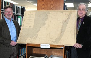
SALISBURY — Many on the Eastern Shore have heard about the fabled Oyster Wars of the Chesapeake Bay, but increasingly few have actually seen a representation of the “battlefields.”
Thanks to Worcester County businessman Reese Cropper III, members of the public will have a chance to see those battle lines more clearly drawn at Salisbury University’s Edward H. Nabb Research Center for Delmarva History and Culture.
Cropper recently donated to the center a 1908 Maryland Shell Fish Commission oyster chart featuring maps of oyster beds in Worcester County.
“We didn’t have any maps that really showed the oyster beds like this one does,” said Dr. G. Ray Thompson, the center’s director. “This may well be one of the few maps left of its kind.”
The rare chart captures a distinct period in Chesapeake Bay history, from the end of the Civil War until roughly 1959, when Eastern Shore watermen went to war over the estuary’s oyster population.
Once Maryland began requiring permits for oyster harvesting in 1865, clashes between legal watermen and “oyster pirates” laying siege to their claims became commonplace, while the Maryland Oyster Navy (forerunner to today’s Maryland Natural Resources Police) attempted to keep the peace and fight illegal practices such as dredging.
The map belonged to Cropper’s great-grandfather, Worcester County surveyor William Dixon Pitts.
“Maps were something that were important to him,” Cropper said.
Cropper remembered his great-grandfather showing him the map during one of his visits as a youngster. He inherited it upon Pitts’ death in 1983.
“Any map is going to be valuable to the Nabb Center for the information it contains for our students and external constituents researching family histories,” Thompson said. “They want to see where their families lived, where their ancestors grew up and, in this case, where their family’s oyster beds were. These were their workplaces.”
