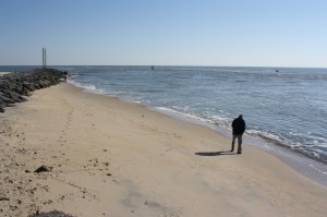
OCEAN CITY — A rare, if never-before-seen, anomaly appeared at the Ocean City Inlet this week in the form of a wide, flat sandy beach on the south side of the north jetty in an typically under water and pounded by waves.
In the wake of Hurricane Sandy, which plowed through the resort area in late October, nearly all of the beaches in the area were altered to some degree and some more than others as sand was eroded from certain areas and deposited in others by the storm. Perhaps the most startling change was revealed this week when a sandy spit of new beach as wide as 25 feet at times depending on the tide appeared on the south side of the rocky north jetty, which, along with the south jetty opposite, provide the bookends for the Inlet created by a storm nearly eight decades ago.
Throughout last weekend, curiosity seekers posed for pictures and walked along the new, albeit, temporary beach. On Monday, some fishermen had set up shop on the new sandy expanse, gaining further access to the deep channel than would normally be afforded by fishing from the jetty. Locals and long-timers this week all agreed they had never seen a sandy beach in that area on the south side of Inlet’s north jetty before.
“In all my years growing up around here, I have never seen the sand beach in that area like that,” said Ocean City Public Works Director Hal Adkins.
Ocean City Engineer Terry McGean, who this week was working with the federal Army Corps of Engineers on a possible solution, was equally taken aback by the sudden appearance of the beach in the Inlet.
“I’m not sure when it popped up,” he said. “I’ve never seen anything like it, and I’ve been around here for 30 years.”
McGean said unique features of Hurricane Sandy likely caused the sudden appearance of the sandy beach in the Inlet. McGean explained the littoral drift moves sand parallel to the shoreline, typically in a north-to-south direction. During Sandy, however, the opposite effect occurred with tons of sand moving from south-to-north, which likely resulted in vast amounts of sand being deposited along the south side of the rocky north jetty.
“The littoral drift typically moves a river of sand from north-to-south, which piles up against the jetty at the Inlet,” he said. “That’s why the beach at the Inlet parking lot is typically so wide. The jetty acts as a dam and blocks sand from flowing naturally to the south. During Sandy, we had very strong winds out of the south and north, which actually resulted in a reversal of the littoral drift.”
McGean explained the ebb shoal, the often visible breakwater near the mouth of the Inlet, sucks sand into the Inlet during an incoming tide and blows sand back out during an outgoing tide. As a result of the littoral drift, sand is typically piled up on the north side of the jetty, while Assateague often gets starved for sand by contrast.
The Army Corps of Engineers was already in the process of planning a thorough survey of all the navigation channels in and around the resort area in the wake of the storm, but the sudden appearance of the beach in the Inlet likely has expedited the process.
“I couldn’t believe my eyes when I saw the pictures,” said Army Corps District Engineer Bob Blama this week. “I’ve never seen anything like that. Somebody better put an umbrella and a chair out there and take a picture because you’ll probably never see it again.”
Blama said the Corps will survey all of the navigation channels from the Inlet to the Isle of Wight to the Sinepuxent Bay to determine which need repairs in the aftermath of the storm. He said the channel through the Inlet has been dredged often in the past, and based on the amount of sand piled up against the north jetty, it will likely need to be done again.
“Years ago, it had to be dredged just about every year, but that hasn’t been the case recently,” he said. “It might be something that corrects itself over time and the way the current rolls through there, it might go away naturally, but it certainly looks like we’ll have to do some work in there. We’ll take a close look at it and do our surveys and determine a course of action.”
Blama said the Corps might utilize the “Currituck,” a huge vessel designed specifically for dredging and redistributing sand that is often deployed in the Ocean City area. The Currituck is a dredge hopper that dredges material from silted-in areas along the coast and deposits it in sand-starved areas, typically along Assateague. The vessel’s hull splits open to fill with sand, closes again, travels to a sand-starved destination and splits its hull open again to deposit the material. The low-draft vessel can get close to shore and deposit sand allowing the natural currents to distribute it.
“It might be as simple as getting the Currituck to get in there and dredge it out and deposit it on Assateague,” he said. “It’s a win-win for everybody. Assateague gets nice, white sand and I get a nice clean channel.”
Meanwhile, McGean said he met with Army Corps and DNR officials on Wednesday to begin exploring a course of action for restoring the storm-ravaged beaches in Ocean City, although it remains uncertain if emergency replenishment will be needed.
“There will need to be some repairs done,” he said. “We saw some pretty significant damage to the dunes, but preliminarily, everything looks pretty good. We had some damage to the crossovers, the plants and the fencing, but the Corps will determine if anything more major is needed.”
