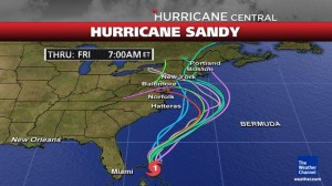
OCEAN CITY — As Hurricane Sandy continues to plod north today, Ocean City and the entire mid-Atlantic region continue to be in the bulls eye for most landfall projections, likely sometime Sunday or early Monday.
The rare late October hurricane on Friday continued to move north of the southeast U.S. coast on Friday morning and is heading to a likely landfall somewhere between Ocean City and Cape Cod although many projections have it coming ashore right over the mid-Atlantic region. The storm, already being dubbed “Frankenstorm” because of its timing around the Halloween holiday, is complicated by a rare configuration of significant weather systems over the region. A strong polar jet stream sweeping across the country coupled with a big low pressure in the north Atlantic is creating a wall of sorts that will likely force Sandy inland rather than allowing it to move to the north and east and out to sea.
Ocean City Emergency Services are continuing to monitor the projected path of Hurricane Sandy. Currently, the storm is expected to be in the Ocean City area during the evening hours of Sunday and is projected to last through Tuesday. High winds and large amounts of rain are likely, which may lead to flooding and power outages.
While Ocean City Emergency Services are monitoring the storm, there has been no official mention of a possible evacuation. Late last August, the town pulled the trigger on an early evacuation of Ocean City as Irene approached, but that storm arrived at the apex of the summer season. If the storm continues on its current path as expected, evacuation recommendations, if not mandatory evacuations, are likely coming.
During the storm, the town of Ocean City will be posting storm-related information on various websites, social media outlets and the GovDelivery system. In an effort to keep citizens informed with the most updated and accurate information, the town of Ocean City will be posting storm-related information on the following outlets: GovDelivery, which can be found on the town’s website under the “city-wide alerts” tab at oceancitymd.gov; town of Ocean City access channels 4 and 15; the emergency management hotline at 410-723-6666; and the AM 1670 advisory radio station.
Throughout the storm, the town of Ocean City’s Emergency Services personnel will be working closely with local and state representatives to provide timely, accurate and essential information. Ocean City encourages residents and business owners to begin to prepare for any impact the storm may have on the resort area. Citizens are advised to prepare an emergency kit and make a family communications plan.
While often accused of hyperbole, forecasters are taking Sandy very seriously with dire predictions for the mid-Atlantic and northeast. The National Weather Service has issued several warnings and alerts up and down the east coast as Sandy continues on its current path.
“Though we feel that it’s likely Sandy will hit some portion of the northeast or mid-Atlantic, there remains uncertainty with the exact timing, location and magnitude of the worst impacts,” the NWS statement reads. “The forecast involves a rare, complex atmospheric setup that will allow the system to pivot back to the northwest into the region rather than simply moving out to sea.”
While most hurricanes that pass through the resort area are 24-hour weather events, Sandy has the potential to linger for multiple days because of the complex weather systems at work, creating a classic nor’easter effect.
“Destructive winds, heavy rain, major coastal flooding and beach erosion would pummel portions of the mid-Atlantic and northeast regions between later Sunday and Tuesday of next week,” the statement reads. “Of course, the high winds would extend inland with the potential for downed trees and power lines. Widespread power outages could last for days.”
A storm’s potential strength is often measured by its atmospheric pressure and Sandy’s could be one of the lowest on record, particularly for how far north it is projected to make landfall. According to the NWS, in the historical best-track database, there have only been six hurricanes with surface pressure at or below 960 millibars within 200 nautical miles of the eastern seaboard north of Virginia Beach to have also made a U.S. landfall.
Those storms will likely be familiar to many in the area including Irene (2011), Gloria (1985), Esther (1961), the “Long Island Express” (1938) and an unnamed storm in 1869. Interestingly, none of those particularly destructive storms occurred in late October. The two most recent examples occurred in late August, and three others- Gloria, Esther and the “Long Island Express” occurred in late September.
As far as comparisons to the “Perfect Storm” around Halloween in 1991, the NWS points out that despite significant damage from coastal flooding, beach erosion and high winds, the center of the “Perfect Storm” never made landfall in the U.S. The lowest central pressure of that historic storm was “only” around 972 and Sandy could have a significantly lower central pressure. As of mid-day on Friday, Sandy’s pressure was 970 millibars and was dropping as it plodded north and west.
A meeting has been set in Ocean City at the Public Safety Building at 5 p.m. where weekend plans will more than likely be discussed.
Gov. Martin O’Malley this afternoon issued a State of Emergency for all Maryland counties. The declaration gives the state flexibility to activate the Maryland National Guard and provide assistance to local emergency managers.
"As Hurricane Sandy makes its way north, I urge all Maryland residents to prepare for extreme weather," said O’Malley. "I urge all Marylanders to review their family emergency plans, make sure their emergency supplies like batteries and water are fully stocked and to stay informed."
